
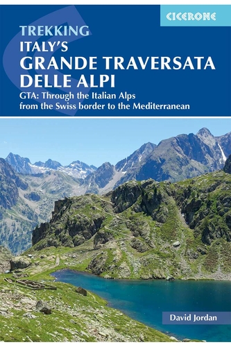
Recommended guidebook: David Jordan, Through the Italian Alps - GTA: The Grande Traversata delle Alpi. Cicerone, 2023. ISBN 9781786310408. "Italy's most rewarding long-distance walking route. An excess of brilliant alpine scenery." Ecco bravo!
The GTA website is in German because the majority of the hikers on the GTA long-distance mountain trail speak German. Now don't panic man you'll NOT be overrun by ze Krauz: there is NO Germoney-based mass tourism as in Austria, Bavaria, Switzerland, or ... Tuscany, because the capacity of the overnight stops is very limited; more often than not they sleep a mere 8 - 10 people! Needless to say, English-speaking hikers from all over the world can make use of our comprehensive GTA website as well, as you will easily understand our continuously updated infrastructure listings. Alternatively you may wish to automatically translate any text or complete websites via Google Translate. In total we have compiled more than 600 printed pages with more than 600 beautiful pictures. The chapters are:
Accommodation: addresses, telephone numbers, warden, opening hours, etc., of all hotels, mountain huts, overnight stops, restaurants, and stores
Trail legs: alternative routes, forks, deviations, junctions, signs, signposts, state of the trail, etc.
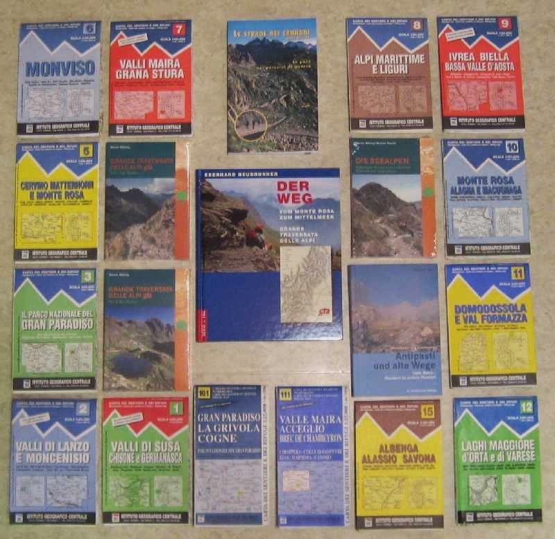
Literature: you can order all guidebooks and maps directly from us
Guided mountain trekkings in the Rimella area
Guided mountain trekkings in the Sesian valley
Attention readers from Belgium and Netherlands: there is a comprehensive webpage in Dutch here!
Regularly updated guidebooks with detailed descriptions of the trail legs, accommodation listings and really comprehensive background information are available in German ONLY, again: because the vast majority of the hikers on the GTA long-distance mountain trail are Germans and Swiss and Austrians and Dutch! There is NOTHING reliable available in Italian. The new editions of Werner Bätzing's famous "GTA Nord" (from the Monte Rosa region down to the Susa valley) and "GTA Süd" (from Susa down to the Ligurian Alps near the Mediterranean Sea) are indispensable guidebooks and - as well as all hiking maps for the whole region - can be conveniently ordered directly from us!
See you up there!
13,000+ selected beautiful pictures for digital photo frames
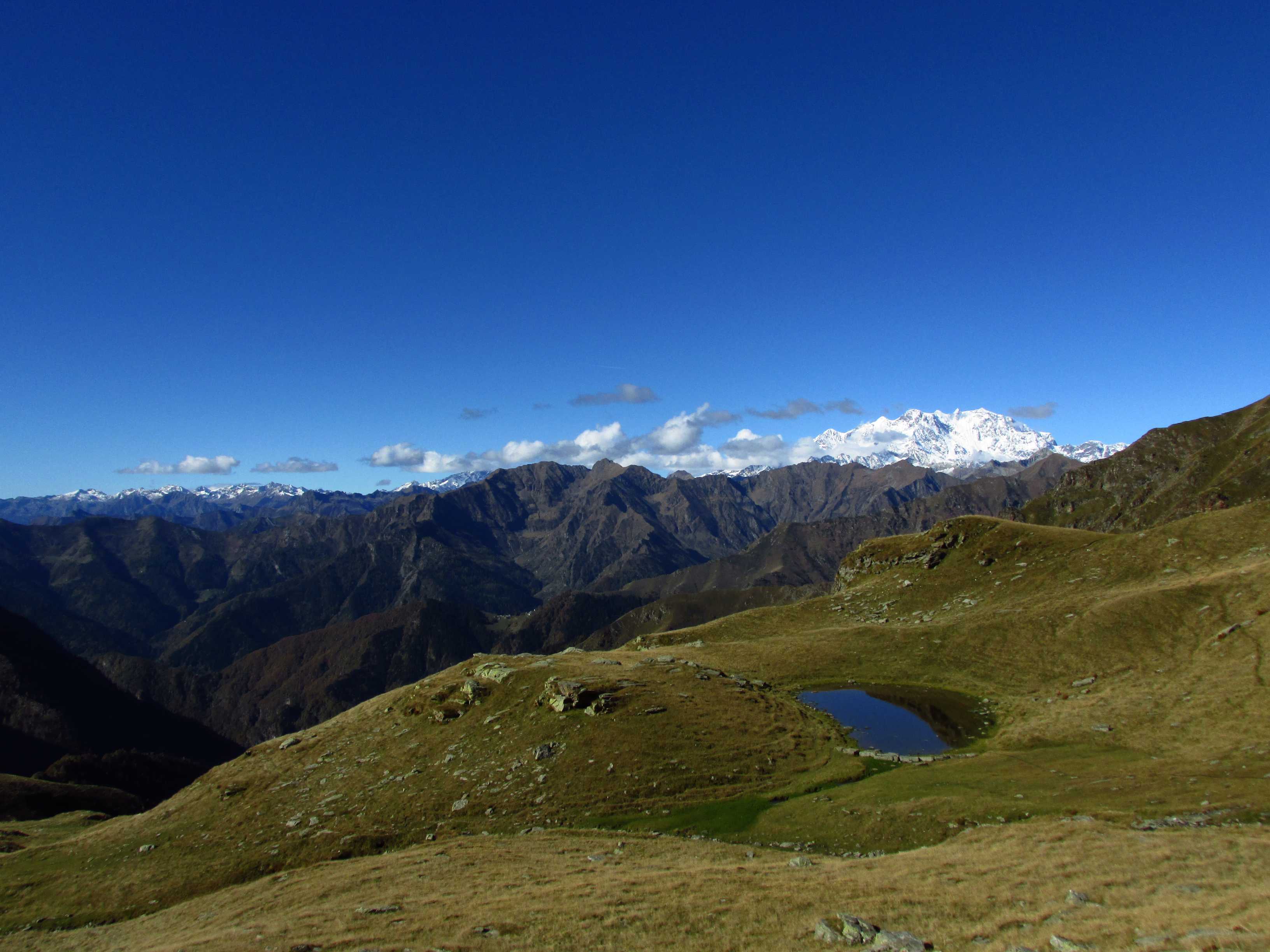
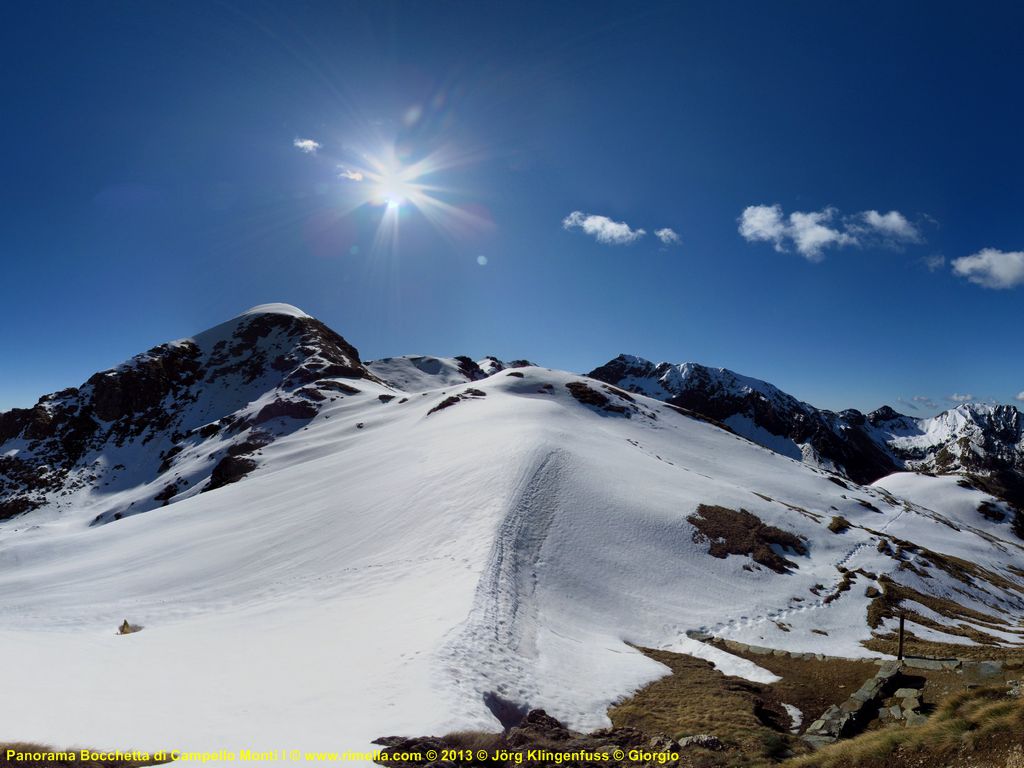
Since 2005, wilderness guide Jörg Klingenfuß has taken more than 28,000 (twenty eight thousand) pictures in Rimella and in the Sesia valley. These cover the large wilderness area of the Mastallone valley, from the surroundings of the small city of Varallo at 500 metres altitude up to the summits of the Mastallone and Strona valleys peaking at more than 2,400 metres, providing spectacular views and panoramas from the momentous massif of the Monte Rosa via the 4,000+ metres high summits of the Wallis down to the vast Lowlands of Northern Italy.
For those who would like to view Rimella and its beautiful surroundings, we offer more than 13,000 (thirteen thousand!) selected superb pictures on a digital memory card. All pictures are labelled with the file name in the lower left corner. Examples:

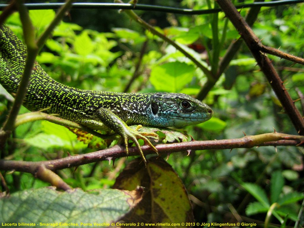
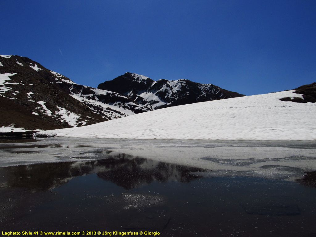
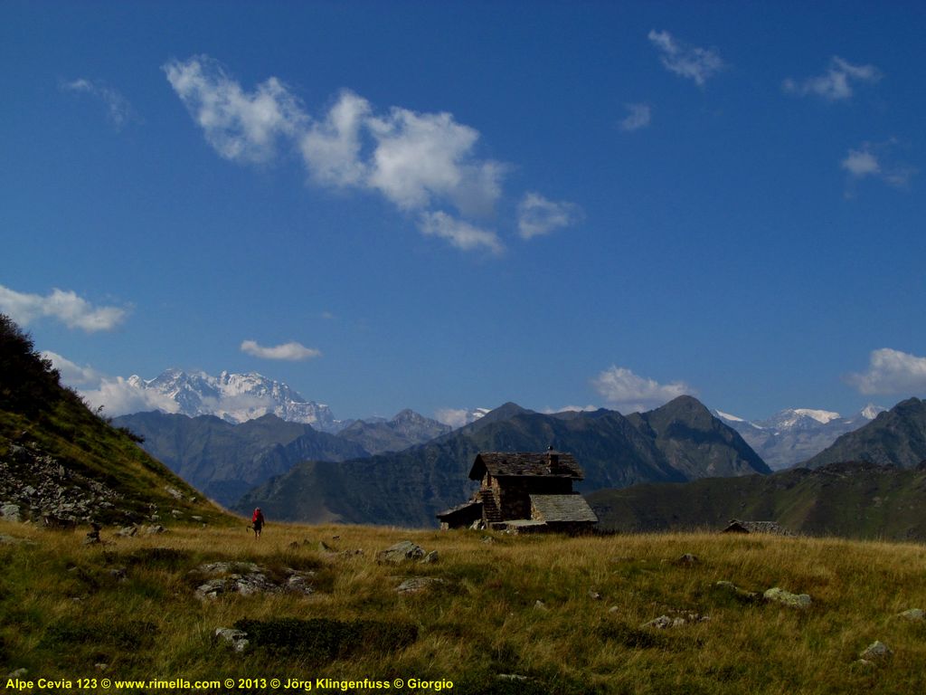
The pictures have been optimized for rapid display in a digital photo frame to the exact format 1024 • 768 pixels, i.e. they are larger than the examples above that have been scaled down to 800 • 600 pixels for this webpage. The generous format 1024 • 768 pixels is used e.g. by the recommendable 10-inches device Intenso Media Gallery. At Amazon this now costs less than 80 EUR, and it has been recommended by TEST November 2010 due to its excellent picture quality - that we perfectly confirm! - in the size 20 • 15 centimetres. - The pictures cover all seasons year round with their full variety, and the period from 2005 to 2019. This unique collection comprises representative sections of our spectacular digital panoramas - in some cases three-dimensional (!) - as well. Media Gallery digital photo frames can be viewed at our friends at Rimella in the Albergo Fontana and in the Bar Monte Càpio, and at Nosuggio in the Osteria Emilia.
We use original SanDisk 4 gigabyte SDHC (Secure Digital High Capacity) memory cards; these have proven as excellent in our digital cameras in the wilderness field. The price of the card with 13,000+ pictures is 80 EUR. Please order here or send us an e-mail at info@rimella.de.
What's more, our archives comprise thousands of pictures, especially macro pictures, of flora and fauna. More than 400 species have been defined according to the biological systematics by means of experts on the spot, Wikipedia, and specialised webpages in the Net. A list of species defined so far can be found here.
Amount of work involved: about 3,100 man hours in the mountains, about 380 man hours on the computer.
"Foto di San Gottardo per pubblicità ... Sono bellissime, grazie." Ely Flori, Rimella, 30. Juni 2016.
"... ich habe mir jetzt alle 5.700 Bilder angesehen, die Du mir in Rimella gegeben hast. Ich bin sehr beeindruckt, weil zahlreiche sehr schöne Aufnahmen dabei sind und weil es letztlich eine einmalige Dokumentation (vor allem von Gebäuden und Siedlungen) ist - der reinste Wahnsinn, eine solch umfangreiche und komplette Dokumentation anzulegen!!!" Prof. Dr. Werner Bätzing, Bamberg, Autor der unentbehrlichen GTA-Wanderführer, 7. Oktober 2015.
"Arrivata la scheda ... ho incominciato a guardare le foto, belle e interessanti ... Le panoramiche sul tuo sito sono spettacolari!" Giorgio Roncaglia, Novara, 5. April 2013.
"Libro 'Valsesia' di S... In tutto questo libro non c'è neanche una foto come le tue. Le tue foto sono le tue foto ... Ormai tutt' la val' le conosce." Emilia, Osteria di Nosuggio di Cravagliana, 2. Oktober 2012.
"Alpe Camplasco ... Che bel pensiero. Questa foto è una meraviglia." Giacomina, 80 Jahre alt, Cravagliana, 26. Juni 2012.
"Volevo ringraziarti delle belle foto per il Museo della Sella." Dr. Ornella Maglione, Responsabile Ecomusei della Regione Piemonte, Torino, 6. Juni 2011.
"Una roba così bella non ho mai vista." Emilia, Osteria di Nosuggio di Cravagliana, 21. Mai 2011, über den digitalen Fotorahmen Intenso Media Creator mit über 12600 Superfotos ...
"Guarda, queste foto sono una meraviglia." Emilia, Osteria di Nosuggio di Cravagliana, 3. August 2010.
"Caro Giorgio, oggiĀhoĀricevutoĀilĀpacco conĀleĀfotografie, mieĀeĀquelleĀdaĀdistribuire, grazie, comeĀalĀsolitoĀmoltoĀbelle ..." Piera Rinoldi, Bar Monte Càpio, Prati di Rimella, 5. November 2009.
"Complimenti per le belle foto!!!!" Flavio Cappelletti, Verbania, 17. November 2006.
The internet is NOT for free. We are a private initiative and NOT a tourist office, tour operator, or travel agency. By consequence, www.gtaweb.de with more than 600 printed pages and more than 600 fotos has to be paid by its users and beneficiaries - that is you! If our extremely comprehensive information has helped to make your GTA trekking a success, we would be grateful for a cash donation. It will be used exclusively for the internet costs and telecom charges that derive from the time-consuming updating of this GTA website. www.gtaweb.de will be continued only if really all GTA hikers contribute to it!
Hagenloher Str. 14
D-72070 Tübingen
Germany
E-Mail info@rimella.de
Member of CAI Varallo Sesia